


The Drowned Wall: A 7,000-Year-Old Mystery Rises From the Atlantic Depths
What if the oldest architects in Europe weren’t farmers, but fisher-hunters? What if legendary sunken cities are not mere myth, but drowned history?
A revolutionary discovery beneath the waves off the coast of Brittany, France, is forcing archaeologists to reimagine the capabilities of ancient societies. A massive, meticulously built stone wall, submerged for millennia, has been unveiled. It predates Egypt’s pyramids and Britain’s Stonehenge. And it whispers secrets of a lost world confronting a rising sea.
The Astonishing Find: A Blueprint from the Stone Age
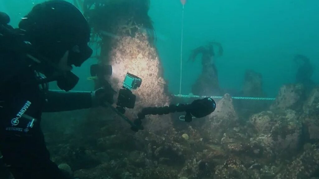
The discovery began not with a dive, but with data. French geologist Yves Fouquet was analyzing seabed charts when a stark, unnatural line emerged from the oceanic scans. It was a silent sentinel, nearly 400 feet long, resting 30 feet below the modern Atlantic surface.
Archaeological teams, led by experts from the University of Western Brittany, have now confirmed it. This is no geological accident. It is a monumental feat of Stone Age engineering.
The structure is staggering in its scale and precision. The wall base stretches an impressive 66 feet wide. It stands, on average, 7 feet tall—a formidable barrier. Crowning its flattened top are dozens of upright stone monoliths, arranged in parallel lines and reaching up to 6 feet high. This was a coordinated, labor-intensive project of mind-blowing ambition.
Anchoring the Find in Time and Tide
The wall’s true age is what cements its global significance. Scientific analysis dates its construction to between 5800 and 5300 B.C.E. This places it firmly in the hands of Mesolithic hunter-gatherers, centuries older than the famous Carnac stone alignments on the Breton mainland.

But the location is the key to the mystery. Today, it’s underwater. Seven thousand years ago, it was on dry land. At the time, sea levels were roughly 23 feet lower. The island of Île de Sein, off whose coast it lies, was a vast, sprawling territory—fourteen times larger than it is today.
The wall was built in the dynamic zone between low and high tide. This precise positioning screams intentionality. The builders were not just working with stone. They were engaging in a daily battle with the ocean itself.
The Burning Question: Why Was It Built?
The “why” fuels electrifying theories. Archaeologists are presented with two compelling, and not mutually exclusive, possibilities.
The first is pragmatic genius: a massive tidal fish trap. As the high tide receded, fish could have been corralled and trapped against this artificial barrier, providing a predictable, abundant food source for a large community.
The second theory is profoundly human: coastal defense. This was an era of rapid climate change and rising seas. The wall could have been a desperate, monumental effort to protect a vulnerable coastal settlement from storm surges and encroaching waters. It is a 7,000-year-old lesson in climate adaptation.
A Society Revealed: More Than Just Survivors
The wall’s construction shatters old stereotypes of small, nomadic Mesolithic bands. This project required a highly organized society.

Quarrying, transporting, and precisely placing these massive granite stones demanded skilled labor, planning, and collective effort. It suggests a settled, hierarchical community with a deep understanding of their environment. The region’s rich marine resources clearly supported a large, stable population capable of monumental works.
Echoes of Myth: The Legend of the Sunken City
This discovery blurs the line between archaeology and legend. Just miles from the site lies the Bay of Douarnenez, the mythical location of the legendary sunken City of Ys from Breton folklore.
Could this wall be a tangible piece of that drowned world? The researchers propose a powerful idea. The rapid sea-level rise that ultimately submerged this structure would have been a cataclysmic, generation-defining event.
The trauma of abandoning a carefully built territory would have etched itself into collective memory. Stories of a great settlement lost to the sea could have been passed down orally for centuries, eventually crystallizing into the myth of Ys. Science and story may finally be converging.
A Global Pattern: Europe’s Drowned Prehistory
The French wall is not an isolated phenomenon. It is part of a revolutionary pattern emerging across Europe’s submerged continental shelves.
In 2024, a stone wall nearly half a mile long, dated to 10,000 years ago, was discovered 70 feet deep in Germany’s Baltic Sea. It is considered the oldest known megastructure in Europe, built by reindeer hunters.

From the Baltic to the Atlantic, these finds reveal a “Doggerland” phenomenon—vast, inhabited landscapes now lost beneath the waves. They form a forgotten chapter of human expansion and ingenuity. Underwater archaeology is now our primary tool for rediscovering this lost coastal world.
What This Means for History: A Paradigm Shift
This discovery is more than a new entry in a catalog of ancient sites. It is a paradigm shift.
It forces us to recognize that some of humanity’s earliest monumental architecture may be hidden on coastlines, not on dry land. It proves that complex social organization and large-scale engineering emerged among hunter-gatherers long before the advent of farming. Finally, it provides stark, ancient testimony to the transformative power of climate change and rising seas—a lesson with undeniable resonance today.
The drowned wall off Brittany is not a ruin. It is a message. It speaks of a sophisticated society that looked at the rising tide and dared to build against it. In its stones, we find not just ancient history, but a mirror to our own epoch.
5 In-Depth FAQs
1. How was the site discovered?
The site was first identified through advanced seabed mapping and sonar technology. French geologist Yves Fouquet noticed the anomalous linear structure on bathymetric charts, which led to targeted archaeological dives and verification.
2. How do we know it’s 7,000 years old?
Dating relies on multiple lines of evidence. While direct radiocarbon dating of organic material trapped in the structure is ongoing, the primary method is contextual. Scientists analyzed sea-level rise models for the region and the geological stratigraphy around the wall. Its construction is pinpointed to the period when that specific part of the coastline was last above sea level, between 5800 and 5300 B.C.E.

3. What makes it more significant than the Carnac stones?
The Carnac alignments in Brittany are Neolithic, built by farming societies around 4500 B.C.E. This submerged wall is Mesolithic, built by hunter-gatherer-fishers at least 500-800 years earlier. It pushes back the timeline for monumental stone construction in Western Europe and attributes it to a different, often underestimated, type of society.
4. Could this be a natural formation?
Archaeologists have definitively ruled this out. The wall’s linearity, the organized placement of upright monoliths in parallel lines, the use of non-local granite blocks, and the sheer scale of the flattened foundation are all hallmarks of human design. The structure has no counterpart in the area’s natural geology.
5. What are the next steps for research?
The priority is non-invasive survey. Researchers will use high-resolution 3D photogrammetry to create a complete digital model. Sediment cores around the base may contain pollen, tools, or organic material for precise dating and environmental analysis. Crucially, they will search for associated structures—huts, hearths, or middens—to understand if this was part of a larger settlement. Every effort will be made to study the site in situ without excavation.